In Oakland, the mix of Franciscan Complex bedrock and young alluvial deposits along the estuary creates sharp velocity contrasts that shallow borings often miss. Many projects here discover unexpected fault splays or buried channels only after excavation begins. Seismic tomography bridges that gap by generating 2D or 3D velocity profiles that reveal layer boundaries, fracture zones, and the top of rock before you break ground. Complementing this method with a georradar GPR survey helps correlate high-resolution velocity data with shallow stratigraphy, especially in the flatlands near Lake Merritt where fill thickness varies block by block.
Oakland’s proximity to the Hayward Fault makes seismic tomography a practical first step to confirm bedrock depth and locate hidden fault splays before design.
Approach and scope
Site-specific factors
Setting up a seismic line along Oakland’s narrow streets or steep hillside lots takes careful planning. The urban environment introduces background noise from BART trains, truck traffic, and construction vibration that can mask first arrivals. Our field crew uses real-time noise monitoring and stacks multiple shots per receiver location to improve signal-to-noise ratio. On slopes above 30 percent, we place geophones with spikes rather than base plates and use survey-grade GPS to correct for elevation changes that would otherwise distort travel-time picks. Missing those corrections in the hills can produce false low-velocity zones that look like soft soil but are actually topography artifacts.
Service video
Relevant standards
ASTM D5777-18 (Standard Guide for Refraction Seismic Methods), ASTM D7128-18 (Standard Guide for Reflection Seismic Methods), ASCE 7-22 (Site Class determination via shear-wave velocity), California Geological Survey Note 48 (Fault-rupture hazard zones)
Related technical services
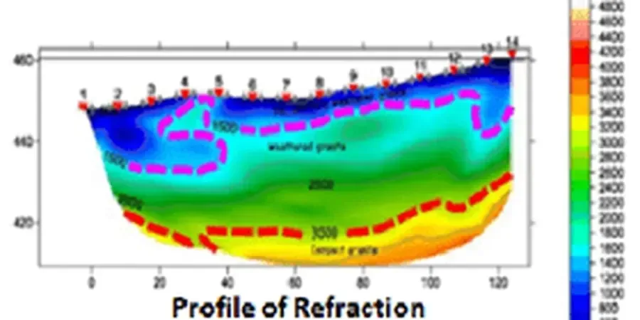
Refraction Tomography (P-wave)
Ideal for mapping the top of bedrock and defining layer contacts in Oakland’s alluvial flats. Uses first-arrival travel times to build a smooth velocity model down to 30 m. Typical for foundation assessments on fill sites near the Port of Oakland.
Reflection Profiling (P-wave)
Resolves thin layers and steeply dipping structures like fault splays that refraction may miss. Applied along linear alignments such as retaining walls, tunnel portals, and pipeline corridors in the Oakland hills.
MASW / Surface-Wave Tomography
Combines active MASW with passive microtremor recordings to derive 1D and 2D shear-wave velocity profiles. Directly provides Vs30 for ASCE 7 site classification, critical for projects located within the Alameda County Seismic Hazard Zone.
Typical parameters
FAQ
How deep can seismic tomography image in Oakland’s soils?
In the alluvial deposits typical of downtown and West Oakland, refraction tomography reliably images down to about 30 meters. In the hills where bedrock is shallower, the practical depth limit is around 15 meters. The actual depth depends on spread length, source energy, and background noise levels at each specific site.
Is seismic tomography effective on steep hillside lots in the Oakland hills?
Yes, but it requires careful survey design. We use shorter geophone arrays (12 to 24 channels) with tighter spacing (1 to 2 meters) to capture the rapid velocity changes caused by irregular weathering profiles. Elevation corrections are critical — we apply a static correction derived from survey-grade GPS to avoid false low-velocity artifacts from topography.
How does seismic tomography compare to borings for fault assessment near the Hayward Fault?
Seismic tomography provides continuous 2D coverage along a line, whereas a boring gives a single point measurement. For fault assessment, tomography can locate secondary fault splays and changes in bedrock elevation that a single boring might miss. We recommend combining both — tomography to define the geometry, then targeted borings to confirm lithology and collect samples for laboratory testing.
What is the typical cost range for a seismic tomography survey in Oakland?
For a standard project, expect a range between US$2,320 and US$6,010. The variation depends on spread length, number of lines, access difficulty, and whether you need both P-wave and S-wave surveys. This estimate includes field acquisition, data processing, and a report with velocity models and interpreted cross-sections.