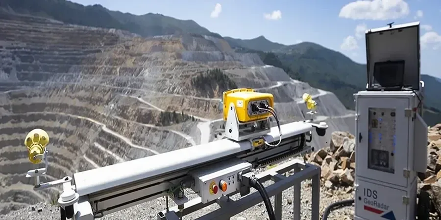
The monitoring team sets up in Oakland with a portable inclinometer probe and a handheld data logger. They walk the slope, lower the probe into a vertical casing, and record tilt readings at half-meter intervals. The instrument measures deflection angles to within 0.01 degree. Back in the office, the data gets plotted against time to spot acceleration trends. For deeper profiles, the crew deploys a MASW survey to map shear-wave velocity contrasts, which helps correlate surface movements with subsurface layering. Each monthly visit produces a clear report showing displacement vectors and pore-pressure changes.
In the Oakland Hills, monthly inclinometer readings have caught acceleration trends three to six months before visible cracking appeared on the surface.
Approach and scope
Site-specific factors
Take two Oakland neighborhoods: the flat alluvial plain near the estuary and the steep slopes of the Montclair district. The plain has deep, uniform clays that settle slowly under load. Montclair, though, sits on colluvium and old landslide debris. A heavy winter rain there can raise pore pressures fast. Monthly geotechnical slope monitoring in Oakland measures that pressure rise before it triggers movement. Without it, a wet season could turn a dormant slide into a house-damaging event. The city's hills have a long history of reactivated landslides, so early detection is critical.
Relevant standards
ASTM D6230-19 (Inclinometer testing), ASTM D4750-87 (Piezometer installation), IBC 2024 Chapter 18 (Excavation and grading)
Related technical services
Inclinometer Surveys
Biaxial tilt readings from pre-installed casings. We provide cumulative displacement plots and rate-of-movement charts. Aluminum or ABS casings are available for permanent installations.
Pore Pressure Monitoring
Vibrating-wire piezometers with dataloggers that record hourly readings. Our team downloads the data monthly and correlates it with local rainfall records from the Oakland gauge station.
Surface Deformation Mapping
Total station or RTK-GPS surveys of monitoring points installed on the slope face. We generate contour maps of vertical and horizontal movement, identifying tension cracks and scarps early.
Typical parameters
FAQ
How does monthly geotechnical slope monitoring work in Oakland?
A technician visits the site every 28 to 35 days. They lower an inclinometer probe into a vertical casing to measure tilt, read pore pressures from piezometers, and survey surface markers with a total station. All data goes into a trend-analysis report.
What is the typical cost for monthly slope monitoring in Oakland?
The typical range is US$410 to US$1,210 per month, depending on the number of inclinometer casings, piezometers, and surface points. A single-casing installation with two piezometers and five surface markers falls near the lower end.
Which Oakland neighborhoods benefit most from slope monitoring?
The Oakland Hills, including Montclair, Claremont, and the Ridgewood district, have the highest landslide risk due to steep terrain and colluvial soils. Properties along the Hayward Fault trace also see differential ground movement that monitoring can detect early.