Oakland sits on complex geology where fill, alluvial fans, and Franciscan bedrock interlace. ASCE 7 and the 2024 IBC require site-specific subsurface data for seismic design in Seismic Design Category D. A GPR (Ground Penetrating Radar) survey provides non-invasive imaging to map buried utilities, voids, and stratigraphy without drilling. This method is especially valuable in Oakland's downtown infill sites where old foundations and undocumented fill layers are common. Combining GPR with calicatas exploratorias for direct verification gives engineers a complete picture before excavation.
GPR survey in Oakland revealed a buried 1920s seawall foundation missed by all existing utility records, saving $180,000 in redesign costs.
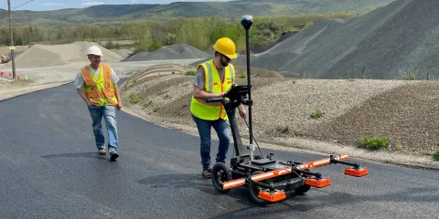
Approach and scope
- 200 MHz antenna for deep utility detection up to 4 m
- 400 MHz antenna for standard rebar and void mapping
- 900 MHz antenna for shallow concrete slabs and thin layers
Site-specific factors
The flatlands of West Oakland sit on Bay Mud and hydraulic fill, while the Oakland Hills rest on fractured sandstone and shale. A GPR survey on Bay Mud can lose signal within 1 m due to high conductivity. In the hills, radar penetration often exceeds 5 m. Missing a buried creek channel or an undocumented fuel tank can halt construction and trigger costly remediation. Our team surveys both zones with calibrated antenna settings and cross-checks results against historical Sanborn maps and boring logs.
Relevant standards
ASTM D6432-19 (Standard Guide for Using GPR for Subsurface Investigation), Caltrans Standard Specifications Section 21 (Utility Location), ASCE 38-22 (Standard Guideline for the Collection and Depiction of Existing Subsurface Utility Data)
Related technical services
Utility locating and mapping
Detect and mark buried pipes, conduits, and cables before excavation. Color-coded maps delivered in CAD format for permit applications.
Void and cavity detection
Identify subsurface voids, sinkholes, and settlement zones under slabs and roads. Critical for Oakland's aging infrastructure corridors.
Reinforcement mapping in concrete
Locate rebar, post-tension cables, and conduits in existing structures. Data supports core drilling and structural assessment.
Archaeological and forensic surveys
Scan for undocumented foundations, old cisterns, or historical artifacts before ground disturbance. Common in Oakland's historic districts.
Typical parameters
FAQ
How deep can GPR penetrate in Oakland soils?
Depth depends on soil type and moisture. In dry sandy soils of the Oakland Hills, GPR reaches up to 8 m. In the Bay Mud of West Oakland, penetration drops to 1-2 m. We select the antenna frequency based on your target depth and local geology.
What is the cost range for a GPR survey in Oakland?
A standard utility mapping survey for a 10,000 sq ft lot in Oakland costs between US$8,630 and US$1,100. Price varies with site size, antenna configuration, and post-processing requirements.
Can GPR detect plastic pipes and fiber-optic cables?
Yes, but with lower contrast than metal. Plastic pipes require a higher frequency antenna (900 MHz) and careful gain adjustment. Fiber-optic cables with dielectric jackets are visible if the surrounding soil has different electrical properties.
How does GPR compare to electromagnetic (EM) utility locating?
GPR detects both conductive and non-conductive targets, while EM only finds metallic objects. GPR also provides depth information and 2D cross-sections. EM is faster for large metallic pipe networks but misses plastic and concrete utilities common in Oakland.